Enter
Before treedrillings can be generated, the BAG layer drillings needs to be active in the map. You can open the layer from the contextmenu. (right mousebutton > Kadaster data > Trees)
By selecting a DP area, the trees in the area are counted and collected from the Tree layer. By clicking on ![]() the current settings are used to check which trees need to have a drilling.
the current settings are used to check which trees need to have a drilling.
By clicking the record in the list, the treedrilling is shown in the map. When 'Generate' is clicked, the drilling are automatically generated.
DP |
Select the DP area, where the Treedrillings need to be generated.
|
Number of Trees |
The field shows the number of trees located withed the selected DP area. If the tree layer is not active, the number will be set to 0, and no drillings can be generated.
|
Drilling type |
Select the type of drillings to be used when generating drillings.
|
Extra length (cm) |
Add a value in cm to add to the drilling as additional length. |
# Ducts |
Set the number of ducts available in the drilling.
|
Material |
Select the duct material. |
Drillingdiameter (mm) |
Set the diameter of the drilling. |
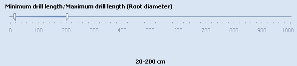
Root diameter |
The field has two sliders, which may be set to determin the minimum drilling length and the maximum drilling length. This matches the minimum length intersecting with a Root diameter and the maximum length intersecting with a Root diameter.
|
|
Alle bomen die binnen de parameters van de zoekactie vallen worden in de lijst getoond. Per boom dient aangegeven te worden of de boring geaccepteerd word. |
|
De bomenboringen worden automatisch aangemaakt.
|
|
Annuleer voorgestelde wijzigingen en sluit het venster.
|

Last edited: 30-03-2018
|
|
© Speer IT B.V. 1999-2018 |